Johannes (Gerard) van Keulen (original publisher)
Remmet Teunisse Backer (after)
J. de Broen (engraver)
Sterre Kaert of Hemels Pleyn, Waer Door Men Kanwetehoelaet Dat Hetis Overde Gehele Aertkloot, Op Alle Meridiane en Polus Hoogte, en, Opwat Lengte en Brete de Voorsz Sterre Staen, Bezuyde en Benoorde de Liniæ Æquinoctiael
[Star Map or Celestial Plan…]
Reinier & Josua Ottens, Amsterdam: c. 1750
Hand-colored engraving
18.25 x 22.5 inches, plate mark
21.5 x 25.5 inches, overall
Sold, please inquire as to the availability of similar items.

Mercator Style Dutch Celestial Chart
Northern & Southern Constellations: c. 1750
Northern & Southern Constellations: c. 1750
This item is sold. It has been placed here in our online archives as a service for researchers and collectors.
- Please inquire as to the availability of similar items currently in stock, or use the navigation bar above to browse our site for currently available items.
- Find guidelines for the use of images from georgeglazer.com.
- To see more archived items, view our directory.
- Find information about selling your art and antiques.
 |
 |
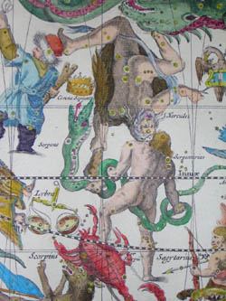 |
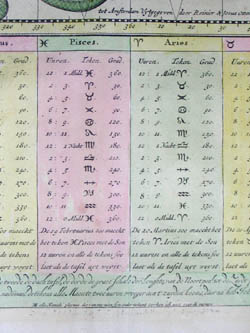
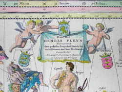
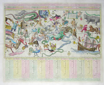
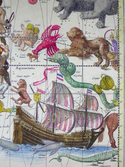
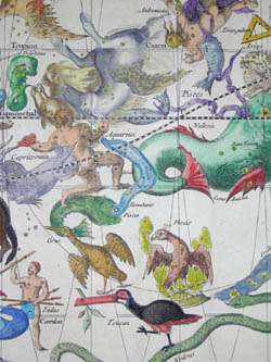
This large map is one of the finest Dutch celestial charts, showing the constellations of both the northern and southern hemispheres on a single projection (analogous to a Mercator projection on a world map). The constellations include those of the northern sky, based on classical mythology, along with the Southern constellations that had been charted and named after they were observed by Dutch voyagers in the 1590s. The constellations are depicted as though looking down on the earth from beyond the stars, so many of the figures are drawn with their backs turned. Cherubs support a subsidiary decorative cartouche in the upper right. A chart of measurements organized by zodiac is provided in the lower portion of the print.
According to Carole Stott, this map was one of two celestial charts included in the atlas Boeck zee-kaardt, published in 1709 by Gerard van Keulen under the name of his father, Johannes van Keulen. The Sterre Kaert of Hemels Pleyn map was reissued in atlases produced by other cartographers throughout the eighteenth century, including this version by the publisher Reinier & Josua Ottens from c. 1750, who added their names to it.
Remmet Teunisse Backer was the artist for the original 1709 version of this chart.
The print was engraved by J. de Broen, most likely Johannes de Broen, a Dutch engraver from Amsterdam. It is known that he was baptized in 1649 and was the elder brother of Gerrit de Broen, also an engraver.
The Ottens print and map publishing firm was founded by Joachim Ottens, a copper engraver. After his death in 1719, his widow and his two sons Reinier (1698-1750) and Josua (1704-1765) Ottens continued the business. In 1750, Reinier died and was succeeded by Josua's son, Reinier II (1729-1793). Ottens is best known for their multi-volume atlases of Dutch maps assembled to order such as Atlas Major. They also produced city and country maps and reissued maps produced by earlier Dutch cartographers.
Subsidiary Cartouche: Door Dit Hemels Pleyn Wert vertoondt den gehelen loop des Hemels der vaste Sterren met haer Beeltenisse tot Euckhuysen met Privilegien
References:
Bénézit, E. Dictionnaire critique et documentaire des Peintres, Sculpteurs, Dessinateurs et Graveurs. France: Librairie Gründ, 1966. Vol. 2, p. 147.
“Reinier Ottens (1698-1750) and Josua Ottens (1704-65), Atlas Major (1745).” University of Wisconsin-Madison Library, Special Collections. 1999-2000. http://www.library.wisc.edu/libraries/SpecialCollections/histcart/frm_otten.htm (6 January 2005).
“Star Chart by Remmet Teunisse Backer, 1709.” National Maritime Museum, UK. http://www.nmm.ac.uk/server/show/conWebDoc.6910 (6 January 2005).
Stott, Carole. Celestial Charts: Antique Maps of the Heavens. New York: Crescent Books, 1991. pp. 88-89.