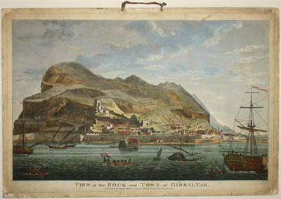
View of the Rock and Town of Gibraltar
Laurie & Whittle, London: August 21, 1809
Hand-colored engraving, mounted on card, as issued
12.5 x 18.5 inches, overall
Sold, please inquire as to the availability of similar items.

View of the Rock and Town of Gibraltar
Laurie & Whittle, London: 1809
Laurie & Whittle, London: 1809
This item is sold. It has been placed here in our online archives as a service for researchers and collectors.
- Please inquire as to the availability of similar items currently in stock, or use the navigation bar above to browse our site for currently available items.
- Find guidelines for the use of images from georgeglazer.com.
- To see more archived items, view our directory.
- Find information about selling your art and antiques.

View
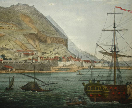
Detail
Full sheet with hanging loop
View of Gibraltar from the harbor on a sunny day, showing the city walls and building built into the rocky hillside. Sailing vessels are anchored in the harbor, and sailors from a clipper ship in the lower right are disembarking into rowboats and heading for the shore. One large rowboat flies the Union Jack. The territory was ceded to Britain by the Spanish crown early in the 18th century, and though the Spanish twice mounted sieges to reclaim it, the last one ending in 1783, it remained under British rule. In 1809, when this print was made, the area was threatened by Napoleon. Spain and Britain joined forces against the French the following year. In this context, the presence of the boat flying the British flag in the center foreground seems intended to underscore to a British audience that this land belonged to their empire.
This view is in the general format and size of a vue d’optique -- a perspective view produced as a hand-colored print generally intended to be viewed through a convex lens. Vues d’optique often were rendered in high-key color and dramatic linear perspective which enhanced the illusion of three-dimensionality when viewed through the lens, making it seem like the viewer was really there. Thus, they served as a form of visual entertainment. The viewing devices were known variously as zograscopes, optiques, optical machines and peepshows. According to the Getty Research Institute, street performers would set up viewing boxes with a series of prints giving a pictorial tour of famous landmarks, dramatic events and foreign lands. Vues d’optique were also purchased by Grand Tour travelers as souvenirs to be viewed at home as a parlor activity. To cater to this broad audience, the prints often had titles and descriptions in two or more languages. Because the images are reversed in viewing devices, the main titles on some vues d’optique are backwards. Vues d’optique were also hung on walls as decoration. This particular rare example is backed on card, as issued, and with a central cloth loop, for hanging without a frame.
Robert Laurie (1755-1836) and James Whittle (1757-1818) were London map, chart and printsellers active from 1794 to 1812 trading variously as Laurie and Whittle or Whittle and Laurie. Laurie began his career as an accomplished mezzotint engraver and exhibited at the Society of Artists from 1770 to 1776. With Whittle, he took over the large map and print business of Robert Sayer. Laurie & Whittle published many atlases and maps and products used for jigsaw puzzles. Robert's son, Richard Holmes Laurie, succeeded him upon his retirement in 1812, and after Whittle's death in 1818 carried on the business alone until at least 1840. The firm still exists as Imray, Laurie, Norie and Wilson Ltd., which has long specialized in marine charts.
Full publication information: “Published 21 August 1809 by Laurie & Whittle No. 53 Fleet Street London.”
References:
“Emperor’s Palace in Beijing.” Devices of Wonder. J. Paul Getty Trust. 2001. http://www.getty.edu/art/exhibitions/devices/html/homepage.html (30 September 2002).
Maxted, Ian. "The London book trades 1775-1800: a preliminary checklist of members." Exeter Working Papers in British Book Trade History. 2001. http://bookhistory.blogspot.com/2007/01/london-1775-1800-l.html and http://bookhistory.blogspot.com/2007/01/london-1775-1800-w-z.html (20 May 2009).