Joan Blaeu (c. 1599-1673) (original publisher)
Amphitheatrum Vespasiani, nunc vulgo Il Coliseo, Plate V
[Vespasian's Amphiteater, Commonly Known as the Coliseum]
from Citta del Vaticano, Roma and Napoli
Pierre Mortier, Amsterdam: 1704-05
Black-and-white engraving
17.5 x 21.25 inches, plate mark
22 x 26.25 inches, overall
Sold, please inquire as to the availability of similar items.

The Coliseum, Rome -- Blaeu & Mortier
Early 18th Century Dutch Engraving
Early 18th Century Dutch Engraving
This item is sold. It has been placed here in our online archives as a service for researchers and collectors.
- Please inquire as to the availability of similar items currently in stock, or use the navigation bar above to browse our site for currently available items.
- Find guidelines for the use of images from georgeglazer.com.
- To see more archived items, view our directory.
- Find information about selling your art and antiques.
 |
 |
 |
 |
 |
To view other works by Blaeu, including maps and city views, type "Blaeu" in our search engine.
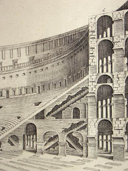
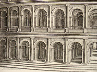
Architectural study Vespasian’s Amphitheater, today known as the Coliseum. Blaeu’s print depicts the structure as an architectural rendering, as it would have looked when originally constructed (rather than in partial ruins). A section is cutout to show the interior and construction details of the façade. A key in the lower margin identifies various parts of the structure. A richly decorated cartouche bearing a coat of arms dedicates the print to a patron of the period.
This engraving was originally published by Joan Blaeu, who published three town-books of Italy during his lifetime: Citta del Vaticano, Roma and Napoli. By the year 1672, a fire largely destroyed the main Blaeu workshop, and much of the prepared material. Nonetheless, work on the town-books continued, and in 1682 the completed work was published in Amsterdam by his heirs. The town-books were a great success and reissued several times by different publishers in Amsterdam, as late as 1726. Pierre Mortier reissued all the Blaeu plates in the years 1704-05 in an atlas comprising four volumes with the imprint of “A Amsterdam Chez P. Mortier Avec Privilege.”
The Blaeu family of cartographers, founded by Willem Janszoon Blaeu (1571-1638) in about 1604, became the largest printer in 17th century Europe and the leading cartographic publisher during the golden age of Dutch map making. Read more about the firm in our Guide to Globe Makers.
Pierre Mortier (1661-1711), a Frenchman, established a publishing house in Amsterdam by around 1685 and published or reissued maps by some of the great French and Dutch mapmakers of the late 17th and early 18th centuries, including Guillaume de L’Isle, Carel Allard, Jan Jansson and Joan Blaeu. After Mortier’s death in 1711, the family continued the business and later joined with Johannes Covens to form the firm Covens and Mortier, which also continued to publish Mortier’s maps and prints.
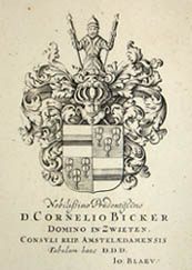
Cartouche: Nobilißimo Prudentißimo/ D. Cornelio Bicker/ Domino in Zwieten,/ Consvli Reip. Amstelædamensis/ Tabulam hanc D. D. D./ Io: Blaev
References:
Fleet, Christopher. "Joan Blaeu." Pont Maps Biographies. National Library of Scotland. 2000. http://www.nls.uk/pont/bio/blaeu.html (17 September 2002).
Tooley, R.V. Maps and Map-Makers. New York: Bonanza Books, 1949. pp. 33-34.